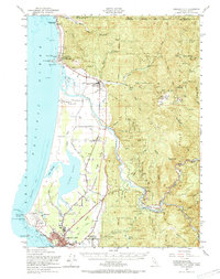
1952 Map of Crescent City
USGS Topo · Published 1969About this map
Crescent City serves as the focal point for this coastal survey, where the rugged Pacific shoreline meets the heavy timberlands of the Klamath Mountains. Along the northern coast, the Smith River winds toward the sea, passing the Smith River Indian Reservation and the historical Yontocket (Indian Village) Site. The interior is marked by the nascent conservation efforts within Jedediah Smith Redwoods State Park, while higher elevations reveal a landscape of active extraction, including the Mountain View Chrome Mines and Alta Copper Mine. Low-lying wetlands are defined by the expansive Lake Earl and Lake Talawa, providing a distinct contrast to the steep drainage of Hardscrabble Creek. The era's transportation network is anchored by the Redwood Highway, connecting the agricultural pockets of Kings Valley Creek and Fort Dick to the regional hub at the bay.
Find a feature on this map
62 named features on this map. Tap any name to fly to it.
Don’t see what you’re looking for? This feature index may not catch every label — zoom into the map to look around manually.
Map Details
Editions of this 1952 Crescent City Map
4 editions found


Other maps of this area

1917 · Kerby
USGS Topo · 1:125,000

1918 · Kerby
USGS Topo · 1:125,000

1922 · Preston Peak
USGS Topo · 1:125,000

1929 · Crescent City
USGS Topo · 1:125,000

1945 · Ship Mountain
USGS Topo · 1:62,500

1945 · Kerby
USGS Topo · 1:125,000

1945 · Gasquet
USGS Topo · 1:62,500

1945 · Point St. George
USGS Topo · 1:62,500

1945 · Requa
USGS Topo · 1:62,500

1948 · Weed
USGS Topo · 1:250,000