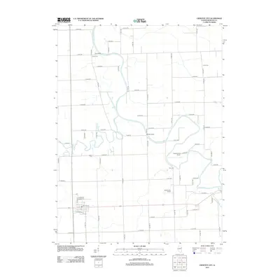
2012 Map of Crescent City
USGS Topo · Published 2012About this map
The Iroquois River meanders through this portion of Iroquois County, defining the agricultural landscape between Crescent City and Watseka. The river's course is punctuated by local landmarks like Plato Bridge in the north and Fiddler Bridge near the center, marking traditional crossing points for the rural road network. Small, family-named burial grounds including Wilson Cem, Lyman Cem, Flesher Cem, and Pierce Cem are scattered across the township, offering specific points of interest for genealogists tracing local heritage.
Find a feature on this map
61 named features on this map. Tap any name to fly to it.
Don’t see what you’re looking for? This feature index may not catch every label — zoom into the map to look around manually.
Map Details
Editions of this 2012 Crescent City Map
This is the sole edition of this map. No revisions or reprints were ever made.
Other maps of this area

1935 · Watseka
USGS Topo · 1:48,000

1938 · Milford
USGS Topo · 1:48,000

1939 · Watseka
USGS Topo · 1:62,500

1939 · Cissna Park
USGS Topo · 1:62,500

1944 · Milford
USGS Topo · 1:62,500

1944 · Gilman
USGS Topo · 1:62,500

1946 · Gilman
USGS Topo · 1:62,500

1949 · Cissna Park
USGS Topo · 1:62,500

1953 · Danville
USGS Topo · 1:250,000

1955 · Danville
USGS Topo · 1:250,000