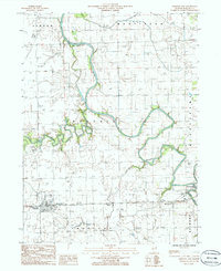
1986 Map of Crescent City
USGS Topo · Published 1986About this map
The confluence of the Middle Fork Iroquois River and the Iroquois River anchor this mid-1980s landscape, illustrating a river-valley geography defined by both natural watercourses and industrial infrastructure. The village of Crescent City sits in the southwest corner, while the western reaches of Watseka are visible to the east along Sugar Creek. This survey highlights the region's agricultural and logistical identity, documented through features like a rural Landing Strip, a series of pipelines, and several localized extraction sites including a Sand Pit and Gravel Pit. Local history is preserved in the location of the Cem and prominent communication landmarks like the Radio Towers WGFA. The map provides a clear look at the township boundaries of Martinton, Ashkum, and Crescent, showing the surveyed sections and transport corridors that connect these Iroquois County communities.
Find a feature on this map
21 named features on this map. Tap any name to fly to it.
Don’t see what you’re looking for? This feature index may not catch every label — zoom into the map to look around manually.
Map Details
Editions of this 1986 Crescent City Map
This is the sole edition of this map. No revisions or reprints were ever made.
Other maps of this area

1935 · Watseka
USGS Topo · 1:48,000

1938 · Milford
USGS Topo · 1:48,000

1939 · Watseka
USGS Topo · 1:62,500

1939 · Cissna Park
USGS Topo · 1:62,500

1944 · Milford
USGS Topo · 1:62,500

1944 · Gilman
USGS Topo · 1:62,500

1946 · Gilman
USGS Topo · 1:62,500

1949 · Cissna Park
USGS Topo · 1:62,500

1953 · Danville
USGS Topo · 1:250,000

1955 · Danville
USGS Topo · 1:250,000