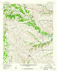
1959 Map of Cresson
USGS Topo · Published 1961About this map
Cresson sits at the southwestern convergence of the Gulf Colorado and Santa Fe and Texas and Pacific railroads, marking a critical transit point in the late 1950s. The landscape is defined by the winding course of the Clear Fork Trinity River and its major tributaries, including Bear Creek and Marys Creek. To the east, the newly formed Benbrook Lake begins to reshape the local topography near Wheatland, where historical burial sites like Keyes Cem and Cori Cem remain preserved. The map documents a rural Texas economy transitioning from livestock ranching, evidenced by the Double L Ranch and Noble Hill Ranch, toward more modern infrastructure. Numerous family cemeteries, such as Hood Cem, Underwood Cem, and O'Neal Cem, are scattered across the rolling terrain between Aledo and Anneta, providing a detailed record for genealogical research in this multi-county border region.
Find a feature on this map
61 named features on this map. Tap any name to fly to it.
Don’t see what you’re looking for? This feature index may not catch every label — zoom into the map to look around manually.
Map Details
Editions of this 1959 Cresson Map
This is the sole edition of this map. No revisions or reprints were ever made.
Other maps of this area

1889 · Granbury
USGS Topo · 1:125,000

1891 · Weatherford
USGS Topo · 1:125,000

1891 · Cleburne
USGS Topo · 1:125,000

1893 · Weatherford
USGS Topo · 1:125,000

1894 · Cleburne
USGS Topo · 1:125,000

1894 · Fort Worth
USGS Topo · 1:125,000

1923 · Granbury 2-a
USGS Topo · 1:48,000

1923 · Granbury 1-b
USGS Topo · 1:48,000

1924 · Weatherford 3-d
USGS Topo · 1:48,000

1928 · Godley
USGS Topo · 1:62,500