
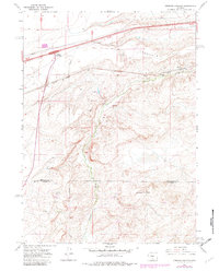
1966 Map of Creston Junction
USGS Topo · Published 1969About this map
The Union Pacific railroad and the 80 highway corridor define the industrial and transit character of this high desert landscape along the border of Sweetwater Co and Carbon Co. In the mid-1960s, the area served as a critical infrastructure hub, marked by a dense network of Pipelines and extractive operations like the Cherokee Mine No 1 and numerous Drill Holes. Small railroad-linked settlements such as Cherokee, Fillmore, and Creston Junction appear alongside service features like the Roadside Park and a lone marked Grave near the highway.
Find a feature on this map
19 named features on this map. Tap any name to fly to it.
Don’t see what you’re looking for? This feature index may not catch every label — zoom into the map to look around manually.
Map Details
Editions of this 1966 Creston Junction Map
2 editions found
Other maps of this area

1954 · Rawlins
USGS Topo · 1:250,000

1958 · Rawlins
USGS Topo · 1:250,000

1962 · Rawlins
USGS Topo · 1:250,000

1966 · Jawbone Ranch
USGS Topo · 1:24,000

1966 · Seaverson Reservoir
USGS Topo · 1:24,000

1966 · Riner
USGS Topo · 1:24,000

1966 · Creston
USGS Topo · 1:24,000

1966 · High Point
USGS Topo · 1:24,000

1966 · Fillmore Ranch
USGS Topo · 1:24,000
1966 · Antelope Spring
USGS Topo · 1:24,000