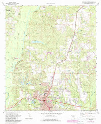
1973 Map of Crestview North
USGS Topo · Published 1987About this map
Crestview serves as the focal point of this survey, showing a period of significant municipal expansion and infrastructure development in Okaloosa County. The map documents the residential grid south of the L & N RR tracks, where streets like Main St and Ferdon St form the commercial core near the City Hall and Po. To the north, the landscape transitions into the wooded tracts of the Blackwater River State Forest, following the winding course of the Yellow River and its numerous tributaries such as Tidwell Mill Creek and Buckhannon Branch. Local industry and community landmarks are well-represented, from the Bob Sikes Airport on the eastern edge to Silver Lake and the Sap Ponds. For genealogists, the map preserves the locations of several rural burial grounds and congregations, including Reeder Cem and New Bethel Ch.
Find a feature on this map
95 named features on this map. Tap any name to fly to it.
Don’t see what you’re looking for? This feature index may not catch every label — zoom into the map to look around manually.
Map Details
Editions of this 1973 Crestview North Map
3 editions found
Other maps of this area

1934 · Holt
USGS Topo · 1:48,000

1934 · Niceville
USGS Topo · 1:48,000

1936 · Niceville
USGS Topo · 1:62,500

1937 · Holt
USGS Topo · 1:62,500

1949 · Crestview
USGS Topo · 1:62,500

1949 · Laurel Hill
USGS Topo · 1:62,500

1950 · Laurel Hill
USGS Topo · 1:62,500

1951 · Crestview
USGS Topo · 1:62,500

1956 · Niceville
USGS Topo · 1:62,500

1956 · Holt
USGS Topo · 1:62,500