
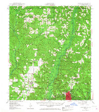
1949 Map of Crestview
USGS Topo · Published 1960About this map
Crestview sits as the hub of this Northwest Florida landscape during the late 1940s, situated at the junction of the Louisville & Nashville railroad and regional roads. The terrain is defined by the convergence of the Blackwater River and Yellow River systems, with much of the northern territory protected within the Conecuh National Forest and Blackwater River State Forest. The map documents a rural society built around small settlements like Escambia Farms, Baker, and Blackman, where life centered on local institutions such as Elm Mission, Magnolia Missionary Ch, and the Campton Sch.
Find a feature on this map
63 named features on this map. Tap any name to fly to it.
Don’t see what you’re looking for? This feature index may not catch every label — zoom into the map to look around manually.
Map Details
Editions of this 1949 Crestview Map
2 editions found
Other maps of this area

1934 · Holt
USGS Topo · 1:48,000

1934 · Harold
USGS Topo · 1:62,500

1934 · Niceville
USGS Topo · 1:48,000

1936 · Niceville
USGS Topo · 1:62,500

1937 · Holt
USGS Topo · 1:62,500

1937 · Harold
USGS Topo · 1:62,500

1938 · Harold
USGS Topo · 1:62,500

1948 · Munson
USGS Topo · 1:62,500

1949 · Laurel Hill
USGS Topo · 1:62,500

1950 · Laurel Hill
USGS Topo · 1:62,500