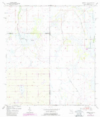
1953 Map of Crewsville SE
USGS Topo · Published 1988About this map
Oak Creek Marsh and its surrounding wetlands dominate this 1950s landscape where the borders of Hardee, De Soto, and Highlands counties converge. The terrain is defined by a complex network of seasonal water and swampy lowlands, including the distinctive Long Point Marsh and the winding course of Oak Creek. The presence of a Levee and an associated Spoil Bank in the eastern section indicates early efforts at water management and land modification in this remote part of Florida. Evidence of human transit and land use is sparse, marked by the lonely Footman Trail and a solitary Windmill, suggesting a period when this region was primarily used for cattle ranching or drainage-dependent agriculture rather than dense settlement.
Find a feature on this map
11 named features on this map. Tap any name to fly to it.
Don’t see what you’re looking for? This feature index may not catch every label — zoom into the map to look around manually.
Map Details
Editions of this 1953 Crewsville SE Map
4 editions found
Other maps of this area

1952 · Sebring
USGS Topo · 1:24,000

1953 · Lake June In Winter
USGS Topo · 1:24,000

1953 · Venus NW
USGS Topo · 1:24,000

1953 · Crewsville SE
USGS Topo · 1:24,000

1953 · Crewsville
USGS Topo · 1:24,000

1956 · Sweetwater
USGS Topo · 1:24,000

1956 · Crewsville SW
USGS Topo · 1:24,000

1956 · Fort Pierce
USGS Topo · 1:250,000

1957 · Long Island Marsh NW
USGS Topo · 1:24,000

1957 · Long Island Marsh NE
USGS Topo · 1:24,000