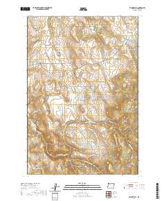
2020 Map of Cricket Flat
USGS Topo · Published 2020About this map
Cricket Flat and Minam Summit anchor this survey of the high plateau and canyon country in eastern Union County. The landscape is defined by a network of drainage systems including N Fork Clark Cr and Middle Fork Clark Cr, which carve through the terrain between prominent landmarks like Stubblefield Mtn and Owenby Hill. Genealogists will find the locations of Highland Cem and Pine Grove Cem particularly valuable for tracing local heritage in this rural corner of Oregon.
Find a feature on this map
44 named features on this map. Tap any name to fly to it.
Don’t see what you’re looking for? This feature index may not catch every label — zoom into the map to look around manually.
Map Details
Editions of this 2020 Cricket Flat Map
This is the sole edition of this map. No revisions or reprints were ever made.
Other maps of this area

1906 · Telocaset
USGS Topo · 1:125,000

1955 · Grangeville
USGS Topo · 1:250,000

1959 · Grangeville
USGS Topo · 1:250,000

1964 · Partridge Creek
USGS Topo · 1:24,000

1964 · Howard Butte
USGS Topo · 1:24,000

1964 · Cricket Flat
USGS Topo · 1:24,000

1964 · Minam
USGS Topo · 1:24,000

1964 · Elgin
USGS Topo · 1:24,000

1964 · Rondowa
USGS Topo · 1:24,000
1965 · Gasset Bluff
USGS Topo · 1:24,000