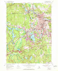
1955 Map of Crompton
USGS Topo · Published 1972About this map
The North Branch Pawtuxet River and its southern counterpart define the industrial and residential heart of this Rhode Island landscape, where a dense corridor of mill towns including Hope, Phenix, and River Point follows the water's edge. This mid-century survey captures the region as suburban expansion began to overlay the older textile-era settlements. In West Warwick, the concentration of schools like Deering High Sch and churches such as St John Ch illustrates the established community density, while further west, the Penn Central rail line cuts through Washington.
Find a feature on this map
102 named features on this map. Tap any name to fly to it.
Don’t see what you’re looking for? This feature index may not catch every label — zoom into the map to look around manually.
Map Details
Editions of this 1955 Crompton Map
3 editions found
Other maps of this area

1887 · Providence
USGS Topo · 1:62,500

1889 · Providence
USGS Topo · 1:62,500

1889 · Burrillville
USGS Topo · 1:62,500

1890 · Narragansett Bay
USGS Topo · 1:62,500

1890 · Kent
USGS Topo · 1:62,500

1892 · Narragansett Bay
USGS Topo · 1:62,500

1894 · Burrillville
USGS Topo · 1:62,500

1894 · Kent
USGS Topo · 1:62,500

1894 · Providence
USGS Topo · 1:62,500

1915 · Burrillville
USGS Topo · 1:62,500