
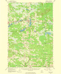
1961 Map of Cromwell
USGS Topo · Published 1963About this map
Cromwell and the surrounding Carlton County townships are defined by a network of lakes and drainage systems established decades before this 1961 field check. The Northern Pacific railroad runs through the center of the region, connecting the settlements of Wright and Cromwell across a landscape of glacial water bodies like Island Lake and Eagle Lake. To the south, the Soo Line passes through the township of Automba, illustrating the era's reliance on rail transport for moving timber and agricultural goods.
Find a feature on this map
48 named features on this map. Tap any name to fly to it.
Don’t see what you’re looking for? This feature index may not catch every label — zoom into the map to look around manually.
Map Details
Editions of this 1961 Cromwell Map
2 editions found
Other maps of this area

1953 · Duluth
USGS Topo · 1:250,000

1954 · Sawyer
USGS Topo · 1:24,000

1954 · Martin Lake
USGS Topo · 1:24,000

1956 · Barnum
USGS Topo · 1:62,500

1958 · Duluth
USGS Topo · 1:250,000

1961 · Moose Lake
USGS Topo · 1:62,500

1962 · Bruno
USGS Topo · 1:62,500

1963 · Gowan
USGS Topo · 1:24,000

1963 · Prairie Lake
USGS Topo · 1:24,000

1969 · Ronald
USGS Topo · 1:24,000