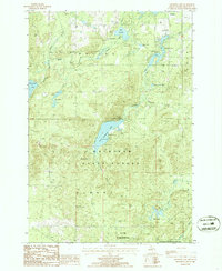
1986 Map of Crooked Lake
USGS Topo · Published 1986About this map
The Mackinaw State Forest dominates this northern Michigan landscape, where the Thunder Bay River winds through the townships of Briley, Avery, and Loud. This mid-1980s provisional survey illustrates a region defined by its hydrography and conservation land, notably the Hunt Creek Fisheries Research Area at the southern edge. The map reveals a dense network of glacial lakes including Crooked Lake, Avery Lake, and the smaller Morning Star Lake, many of which feature public access points and campgrounds.
Find a feature on this map
27 named features on this map. Tap any name to fly to it.
Don’t see what you’re looking for? This feature index may not catch every label — zoom into the map to look around manually.
Map Details
Editions of this 1986 Crooked Lake Map
2 editions found
Other maps of this area

1949 · Lewiston
USGS Topo · 1:62,500

1950 · Lewiston
USGS Topo · 1:24,000

1950 · Comstock Hills
USGS Topo · 1:24,000

1951 · Comstock Hills
USGS Topo · 1:24,000

1951 · Lewiston
USGS Topo · 1:24,000

1954 · Hetherton
USGS Topo · 1:62,500

1954 · Traverse City
USGS Topo · 1:250,000

1955 · Atlanta
USGS Topo · 1:62,500

1955 · Comins
USGS Topo · 1:62,500

1955 · Cheboygan
USGS Topo · 1:250,000