1986 Map of Crossett
USGS Topo · Published 1989About this map
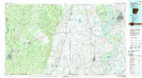
The Missouri Pacific RR anchors the transportation network of this multi-state region, linking the timber and agricultural hubs of Crossett and Hamburg. This mid-1980s landscape reflects the transition from the dense forests of the Overflow National Wildlife Refuge to the productive bottomlands of the Mississippi River valley. Water dominates the eastern half of the sheet, where the Mississippi River carves a complex path past Woodstock Island and Archer Island. Significant conservation areas, including the Cutoff Creek State Wildlife Management Area and Lake Chicot State Park, preserve the natural oxbows and wetlands that define the border between Arkansas, Louisiana, and Mississippi. Small rural communities like Montrose, Portland, and Parkdale line the rail corridors, while landmarks such as Millers Chapel and several regional airfields suggest the dispersed nature of settlement in this riverine landscape.
Find a feature on this map
134 named features on this map. Tap any name to fly to it.
Don’t see what you’re looking for? This feature index may not catch every label — zoom into the map to look around manually.
Map Details
Editions of this 1986 Crossett Map
2 editions found

Historical Maps of Greenville Through Time
1 maps found