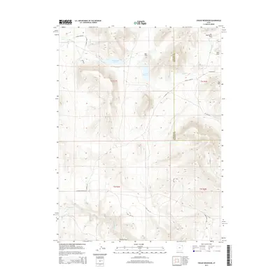
2014 Map of Crouse Reservoir
USGS Topo · Published 2014About this map
Diamond Mt and the high country of the Utah-Colorado borderland dominate this 2014 survey, where the complex hydrography of Uintah Co and Daggett Co meets. The landscape is defined by its water management and drainage systems, featuring the Zelph Calder Reservoir and the nearby Crouse Reservoir. These high-elevation water bodies are supported by the Calder Ditch, which redirects flow across the high plateaus. The map details a network of ranching and access roads, including W Cook Ranch Rd and the E Obrien Ranch Loop, tracing the pathways of early 21st-century land use in this arid region. Deep erosional features like Dead Horse Draw and Diamond Gulch cut through the terrain toward Jones Hole Cr, illustrating the powerful drainage patterns that have shaped the geological character of the northeastern Uintah Basin.
Find a feature on this map
27 named features on this map. Tap any name to fly to it.
Don’t see what you’re looking for? This feature index may not catch every label — zoom into the map to look around manually.
Map Details
Editions of this 2014 Crouse Reservoir Map
This is the sole edition of this map. No revisions or reprints were ever made.
Other maps of this area

1885 · Ashley
USGS Topo · 1:250,000

1950 · Blair Basin
USGS Topo · 1:24,000

1952 · Warren Draw
USGS Topo · 1:24,000

1952 · Swallow Canyon
USGS Topo · 1:24,000

1954 · Vernal
USGS Topo · 1:250,000

1955 · Island Park
USGS Topo · 1:24,000

1955 · Jones Hole
USGS Topo · 1:24,000

1958 · Vernal
USGS Topo · 1:250,000

1960 · Vernal
USGS Topo · 1:250,000
1966 · Jensen Ridge
USGS Topo · 1:24,000