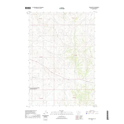
2020 Map of Crow Agency SE
USGS Topo · Published 2020About this map
Little Bighorn Battlefield National Monument anchors the southwest corner of this landscape, marking the site of one of the most significant conflicts in Western American history. The terrain is defined by a series of drainages that flow through the Big Horn County foothills, including Medicine Tail Cr and the geographically significant Medicine Tail Coulee. These features represent the complex topography where tactical movements occurred during the 1876 battle, providing a spatial context for the primary historical event.
Find a feature on this map
15 named features on this map. Tap any name to fly to it.
Don’t see what you’re looking for? This feature index may not catch every label — zoom into the map to look around manually.
Map Details
Editions of this 2020 Crow Agency SE Map
This is the sole edition of this map. No revisions or reprints were ever made.
Other maps of this area

1894 · Rosebud
USGS Topo · 1:125,000

1901 · Rosebud
USGS Topo · 1:125,000

1954 · Hardin
USGS Topo · 1:250,000

1957 · Hardin
USGS Topo · 1:250,000

1958 · Hardin
USGS Topo · 1:250,000

1967 · Jeans Fork NW
USGS Topo · 1:24,000

1967 · Crow Agency NE
USGS Topo · 1:24,000

1967 · Crow Agency SE
USGS Topo · 1:24,000

1967 · Lodge Grass NE
USGS Topo · 1:24,000
1967 · Benteen
USGS Topo · 1:24,000