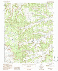
1985 Map of Crow Mesa East
USGS Topo · Published 1985About this map
Crow Mesa dominates the high desert terrain of the Colorado Plateau in the mid-1980s, where the high-altitude landscape of northern New Mexico is carved by an intricate network of deep drainages. This survey documents a critical period of industrial presence in the area, specifically noted by the BCO Camp and several transmission and pipelines that traverse the plateau. The complex topography is defined by the convergence of major erosional features like Largo Canyon and Rockhouse Canyon, which dictate the movement through this arid environment. Significant mesa formations including Blue Mesa and Little Blue Mesa overlook the seasonal watercourses of Crow Canyon and the Blanco Wash near the southern border. This map serves as a detailed record of the intersections between natural landforms and the energy infrastructure that marked the region's development during this era.
Find a feature on this map
15 named features on this map. Tap any name to fly to it.
Don’t see what you’re looking for? This feature index may not catch every label — zoom into the map to look around manually.
Map Details
Editions of this 1985 Crow Mesa East Map
This is the sole edition of this map. No revisions or reprints were ever made.
Other maps of this area

1889 · Largo
USGS Topo · 1:250,000

1895 · Largo
USGS Topo · 1:250,000

1954 · Aztec
USGS Topo · 1:250,000

1958 · Aztec
USGS Topo · 1:250,000

1959 · Nageezi
USGS Topo · 1:62,500

1962 · Aztec
USGS Topo · 1:250,000

1963 · Tayfoya Canyon
USGS Topo · 1:24,000

1963 · Gonzales Mesa
USGS Topo · 1:24,000

1965 · Aztec
USGS Topo · 1:250,000

1966 · Lybrook NW
USGS Topo · 1:24,000