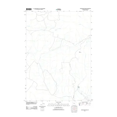
2012 Map of Crow Mountain
USGS Topo · Published 2012About this map
Crow Mountain stands as the central high ground in this area of Fremont County, where a network of seasonal and perennial drainages shapes the remote high-desert topography. The southern reach of the map is defined by the significant incision of Crow Creek Canyon, through which Crow Cr flows. This drainage system is the primary navigational corridor for the area, paralleled by Crow Creek Rd. The landscape is dotted with vital water sources in an otherwise arid environment, including Cantell Spring and the headwaters of Wildcat Cr and Spring Cr. Further north, the terrain transitions toward Trail Cr and Buck Cr, illustrating the complex watershed patterns that dictate land use and livestock movement in this part of Wyoming.
Find a feature on this map
9 named features on this map. Tap any name to fly to it.
Don’t see what you’re looking for? This feature index may not catch every label — zoom into the map to look around manually.
Map Details
Editions of this 2012 Crow Mountain Map
This is the sole edition of this map. No revisions or reprints were ever made.
Other maps of this area

1904 · Kirwin
USGS Topo · 1:125,000

1906 · Kirwin
USGS Topo · 1:125,000

1952 · Wilderness
USGS Topo · 1:24,000

1952 · Crowheart NW
USGS Topo · 1:24,000

1952 · Blue Holes
USGS Topo · 1:24,000

1955 · Thermopolis
USGS Topo · 1:250,000

1958 · Thermopolis
USGS Topo · 1:250,000

1962 · Thermopolis
USGS Topo · 1:250,000
1967 · Bain Draw
USGS Topo · 1:24,000

1967 · Monument Peak
USGS Topo · 1:24,000