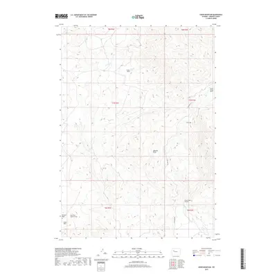
2017 Map of Crow Mountain
USGS Topo · Published 2017About this map
The Absaroka Range anchors this high-elevation landscape in Fremont County, where the terrain is defined by a complex network of draws and basins. Rising prominently in the center of the sheet, Crow Mtn stands as a significant landmark above the surrounding Crow Creek Basin and the deep incision of Crow Creek Canyon. This 2017 survey details a remote wilderness environment where water sources like Cantell Spring and ephemeral drainages including Wildcat Cr and Buck Cr dictate the character of the land. Human presence is minimal, marked primarily by the winding path of Crow Creek Rd and a few named agricultural or geographic features such as Windmill Draw and the flat expanse of Lower Table. The map provides a contemporary view of these traditional grazing and ranching lands, showing how the topography transitions from the steep slopes of the Absarokas down into the varied elevations of East Fork Jenkins Draw.
Find a feature on this map
21 named features on this map. Tap any name to fly to it.
Don’t see what you’re looking for? This feature index may not catch every label — zoom into the map to look around manually.
Map Details
Editions of this 2017 Crow Mountain Map
This is the sole edition of this map. No revisions or reprints were ever made.
Other maps of this area

1904 · Kirwin
USGS Topo · 1:125,000

1906 · Kirwin
USGS Topo · 1:125,000

1952 · Wilderness
USGS Topo · 1:24,000

1952 · Crowheart NW
USGS Topo · 1:24,000

1952 · Blue Holes
USGS Topo · 1:24,000

1955 · Thermopolis
USGS Topo · 1:250,000

1958 · Thermopolis
USGS Topo · 1:250,000

1962 · Thermopolis
USGS Topo · 1:250,000
1967 · Bain Draw
USGS Topo · 1:24,000

1967 · Monument Peak
USGS Topo · 1:24,000