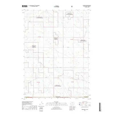
2017 Map of Crowe Dam
USGS Topo · Published 2017About this map
Buffalo Gap National Grassland dominates this western landscape, where the high plains transition across the border between South Dakota and Nebraska. The terrain is defined by a dendritic drainage network, with seasonal watercourses like Coal Cr, Duck Cr, and Crow Cr carving paths through the grassland. This 2017 survey reveals a largely open territory managed for conservation and grazing, punctuated by small-scale human intervention such as Crowe Dam near the northern boundary. The cartography illustrates the intersection of Fall River Co, South Dakota, and Sioux Co, Nebraska, tracing the jurisdictional lines that divide this remote segment of the Great Plains. A sparse grid of county roads, including Co HWY 7a and Co HWY 6412, provides the primary access through the townships, which remain largely undeveloped and dedicated to the preservation of the shortgrass prairie ecosystem.
Find a feature on this map
20 named features on this map. Tap any name to fly to it.
Don’t see what you’re looking for? This feature index may not catch every label — zoom into the map to look around manually.
Map Details
Editions of this 2017 Crowe Dam Map
This is the sole edition of this map. No revisions or reprints were ever made.
Other maps of this area

1902 · Edgemont
USGS Topo · 1:125,000

1950 · Rumford
USGS Topo · 1:24,000

1955 · Hot Springs
USGS Topo · 1:250,000

1955 · Alliance
USGS Topo · 1:250,000

1957 · Alliance
USGS Topo · 1:250,000

1958 · Alliance
USGS Topo · 1:250,000

1980 · Montrose
USGS Topo · 1:24,000
1980 · Story
USGS Topo · 1:24,000
1980 · Story NE
USGS Topo · 1:24,000
1982 · Crowe Dam
USGS Topo · 1:25,000