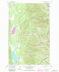
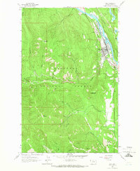
1963 Map of Crowell Mountain
USGS Topo · Published 1984About this map
Bull Lake dominates the southwestern corner of this landscape, serving as a focal point for the recreational and natural features along the border of Kootenai National Forest and Kaniksu National Forest. The presence of the Dorr Skeels Campground and Callows Island suggests a well-established pattern of outdoor access in the early 1960s. The terrain transitions from the lowlands of Lake Creek up toward the high summits of the Cabinet Mountains, including landmarks like Crowell Mountain and Doonan Peak. The drainage patterns are intricate, with numerous named waterways such as Copper Creek and Porcupine Creek carving through the slopes. This survey also records the Idaho State Line and the county boundary between Lincoln and Sanders counties, while a lone Gravel Pit indicates local industrial activity within the timbered valleys.
Find a feature on this map
32 named features on this map. Tap any name to fly to it.
Don’t see what you’re looking for? This feature index may not catch every label — zoom into the map to look around manually.
Map Details
Editions of this 1963 Crowell Mountain Map
3 editions found
Other maps of this area

1920 · Libby
USGS Topo · 1:125,000

1930 · Libby
USGS Topo · 1:125,000

1932 · Libby
USGS Topo · 1:125,000

1957 · Kalispell
USGS Topo · 1:250,000

1960 · Kalispell
USGS Topo · 1:250,000

1961 · Kalispell
USGS Topo · 1:250,000

1963 · Scenery Mountain
USGS Topo · 1:24,000
1963 · Spar Lake
USGS Topo · 1:24,000
1963 · Troy
USGS Topo · 1:24,000

1963 · Treasure Mountain
USGS Topo · 1:24,000