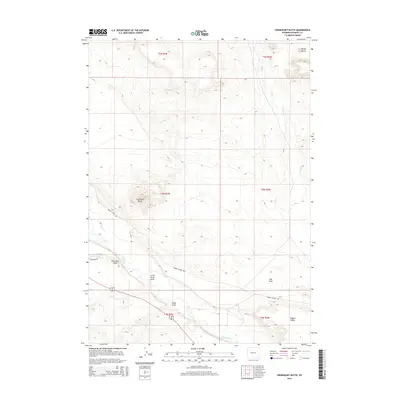
2015 Map of Crowheart Butte
USGS Topo · Published 2015About this map
Crowheart Butte rises as a prominent landmark in this section of Fremont County, anchoring a landscape defined by dramatic elevation changes and a network of ephemeral drainage systems. The Wind River flows through the southern portion of the quadrangle, serving as the primary hydrological feature in an otherwise arid environment characterized by significant formations like Teapot Butte and the extensive Stagner Ridge. The terrain is marked by numerous erosional features, including Cleveland Draw, Little Sand Draw, and Ega Draw, which trace the movement of water toward the river basin. Transportation through this remote territory is primarily facilitated by Burris Lenore Rd, which skirts the base of the buttes. The map provides a clear view of the Public Land Survey System township and range grid, illustrating the spatial organization of this part of the Wind River Indian Reservation during the early 21st century.
Find a feature on this map
16 named features on this map. Tap any name to fly to it.
Don’t see what you’re looking for? This feature index may not catch every label — zoom into the map to look around manually.
Map Details
Editions of this 2015 Crowheart Butte Map
This is the sole edition of this map. No revisions or reprints were ever made.
Other maps of this area

1951 · Lookout Butte SW
USGS Topo · 1:24,000

1951 · Bull Lake East
USGS Topo · 1:24,000

1951 · Argo Butte
USGS Topo · 1:24,000

1951 · Maverick Spring
USGS Topo · 1:24,000

1952 · Crowheart Butte
USGS Topo · 1:24,000

1952 · Crowheart NW
USGS Topo · 1:24,000

1952 · Crowheart NE
USGS Topo · 1:24,000

1952 · Bull Lake West
USGS Topo · 1:24,000

1952 · Crowheart
USGS Topo · 1:24,000

1955 · Thermopolis
USGS Topo · 1:250,000