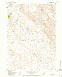
1957 Map of Crowheart NE
USGS Topo · Published 1958About this map
The Wind River Indian Reservation landscape is defined by its industrial activity and drainage networks in the late 1950s. The topography is dominated by the Northwest Sheldon Dome Field, where numerous oil wells, including several marked as dry, are scattered among storage Tanks and an Airstrip. This petroleum infrastructure is concentrated near the center of the sheet, illustrating the mid-century energy development within the reservation boundaries.
Find a feature on this map
17 named features on this map. Tap any name to fly to it.
Don’t see what you’re looking for? This feature index may not catch every label — zoom into the map to look around manually.
Map Details
Editions of this 1957 Crowheart NE Map
3 editions found

Other maps of this area

1904 · Kirwin
USGS Topo · 1:125,000

1906 · Kirwin
USGS Topo · 1:125,000

1951 · Lookout Butte SW
USGS Topo · 1:24,000

1951 · Maverick Spring
USGS Topo · 1:24,000

1952 · Antelope Ridge
USGS Topo · 1:24,000

1952 · Crowheart Butte
USGS Topo · 1:24,000

1952 · Crowheart NW
USGS Topo · 1:24,000

1952 · Crowheart NE
USGS Topo · 1:24,000

1952 · Crowheart
USGS Topo · 1:24,000

1955 · Thermopolis
USGS Topo · 1:250,000