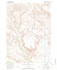
1952 Map of Crowheart NW
USGS Topo · Published 1973About this map
The Wind River Indian Reservation landscape is defined by the carved paths of Crow Creek and the Wind River in this mid-century survey of Fremont County. The topography reflects an arid environment where water management was critical to local life, evidenced by the presence of Lannigans Ditch in the southwestern portion of the sheet. This irrigation infrastructure suggests the early efforts to sustain agriculture or ranching in a region otherwise dominated by natural drainage features like Ega Draw and Red Cr. Distinctive geomorphological features, such as the Sand Dunes near the river bend, highlight the specialized terrain within this section of the reservation. The map captures the area as it was documented in the late 1940s and early 1950s, preserving the natural and man-made watercourses that shaped the development of these tribal lands.
Find a feature on this map
7 named features on this map. Tap any name to fly to it.
Don’t see what you’re looking for? This feature index may not catch every label — zoom into the map to look around manually.
Map Details
Editions of this 1952 Crowheart NW Map
4 editions found
Other maps of this area

1904 · Kirwin
USGS Topo · 1:125,000

1906 · Kirwin
USGS Topo · 1:125,000

1952 · Wilderness
USGS Topo · 1:24,000

1952 · Crowheart Butte
USGS Topo · 1:24,000

1952 · Crowheart NW
USGS Topo · 1:24,000

1952 · Crowheart NE
USGS Topo · 1:24,000

1952 · Crowheart
USGS Topo · 1:24,000

1952 · Burris
USGS Topo · 1:24,000

1955 · Thermopolis
USGS Topo · 1:250,000

1957 · Crowheart NE
USGS Topo · 1:24,000