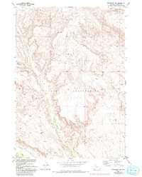
1952 Map of Crowheart NW
USGS Topo · Published 1993About this map
The Wind River Indian Reservation landscape is defined by its dramatic arid topography and critical water management systems in this mid-century survey. The terrain is marked by the course of Crow Creek as it winds southward toward the Wind River, which clips the southwestern corner of the quadrangle. Significant human modification of the natural hydrology is evident through Lannigans Ditch, a feature reflecting the importance of irrigation and water rights in the Wyoming basin. A prominent field of Sand Dunes sits in the lower valley, showing the movement of sediments against the backdrop of deep coulees like Ega Draw. This map preserves the 1952 state of the land with later 1970s updates, documenting a region where survival and settlement were tied directly to the precious flow of the river and its tributaries.
Find a feature on this map
7 named features on this map. Tap any name to fly to it.
Don’t see what you’re looking for? This feature index may not catch every label — zoom into the map to look around manually.
Map Details
Editions of this 1952 Crowheart NW Map
4 editions found
Other maps of this area

1904 · Kirwin
USGS Topo · 1:125,000

1906 · Kirwin
USGS Topo · 1:125,000

1952 · Wilderness
USGS Topo · 1:24,000

1952 · Crowheart Butte
USGS Topo · 1:24,000

1952 · Crowheart NW
USGS Topo · 1:24,000

1952 · Crowheart NE
USGS Topo · 1:24,000

1952 · Crowheart
USGS Topo · 1:24,000

1952 · Burris
USGS Topo · 1:24,000

1955 · Thermopolis
USGS Topo · 1:250,000

1957 · Crowheart NE
USGS Topo · 1:24,000