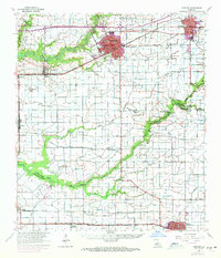
1955 Map of Crowley
USGS Topo · Published 1971About this map
The rice-growing heart of Acadia Parish is centered on Crowley and Rayne in this mid-century look at the Louisiana prairie. The landscape is defined by an extensive network of irrigation canals, such as the Hunter Canal and Gueydan Canal, which supported the region's agricultural economy. This 1955 survey, updated with 1971 urban expansions, shows the Southern Pacific railroad corridor linking established settlements like Estherwood, Midland, and Kaplan.
Find a feature on this map
54 named features on this map. Tap any name to fly to it.
Don’t see what you’re looking for? This feature index may not catch every label — zoom into the map to look around manually.
Map Details
Editions of this 1955 Crowley Map
4 editions found
Other maps of this area

1932 · Abbeville NW
USGS Topo · 1:31,680

1934 · Duson
USGS Topo · 1:31,680

1935 · Branch
USGS Topo · 1:31,680

1946 · Morse
USGS Topo · 1:31,680

1946 · Leroy
USGS Topo · 1:31,680

1946 · Schooner Bayou NE
USGS Topo · 1:31,680

1946 · Schooner Bayou NW
USGS Topo · 1:31,680

1946 · Mermentau
USGS Topo · 1:31,680

1946 · Kaplan
USGS Topo · 1:31,680

1946 · Rayne
USGS Topo · 1:31,680