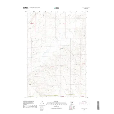
2020 Map of Crowley Dam
USGS Topo · Published 2020About this map
Crowley Dam sits at the center of this sparse landscape in the northern Missouri River breaks region of Montana. The terrain is defined by a network of drainage channels including Alkali Cr and Howard Cr, which carve through the high plains. This map documents a transitional zone where the southern boundary of Petroleum County meets Musselshell County, a region characterized by its expansive ranching tracts and open range. Survey lines for Township 12 North and Range 27 East establish the primary grid across this portion of the Big Snowy Mountains foothills. Local access is maintained through gravel routes like Flatwillow Rd and Kelley Rd, which follow the natural contours of the land. Geographic features such as Jim Coulee and Howard Coulee illustrate the erosional patterns of the central Montana benchlands, providing critical landmarks in a territory with few permanent structures.
Find a feature on this map
15 named features on this map. Tap any name to fly to it.
Don’t see what you’re looking for? This feature index may not catch every label — zoom into the map to look around manually.
Map Details
Editions of this 2020 Crowley Dam Map
This is the sole edition of this map. No revisions or reprints were ever made.
Other maps of this area

1954 · Roundup
USGS Topo · 1:250,000

1958 · Roundup
USGS Topo · 1:250,000

1963 · Kelley
USGS Topo · 1:24,000

1963 · Petrolia Lake
USGS Topo · 1:24,000

1963 · Musselshell NW
USGS Topo · 1:24,000

1986 · Flatwillow
USGS Topo · 1:24,000

1986 · Crowley Dam
USGS Topo · 1:24,000

1986 · Big Wall NW
USGS Topo · 1:24,000
1986 · Yellow Water Reservoir
USGS Topo · 1:24,000
1986 · Jim Coulee
USGS Topo · 1:24,000