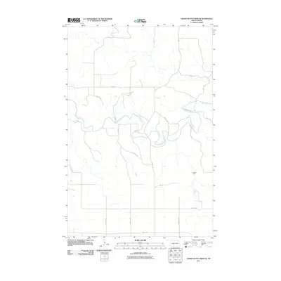
2011 Map of Crown Butte Creek SE
USGS Topo · Published 2011About this map
The Heart River meanders across this Grant County landscape, carving a complex riparian corridor through a region defined by its wide, open spaces and a rigid section-line road network. This 2011 survey reveals the intersection of natural hydrology and human engineering, most notably at Shriek Dam, where local water management shapes the prairie environment. The area is gridded by rural routes like 57th St SW and 53rd Ave, highlighting the systematic land division characteristic of the North Dakota plains. This map is particularly valuable for tracing the exact alignment of these county roads and the specific bends of the river as they appeared during the early 21st century, providing a clear record of the rural infrastructure in a sparsely populated agricultural heartland.
Find a feature on this map
16 named features on this map. Tap any name to fly to it.
Don’t see what you’re looking for? This feature index may not catch every label — zoom into the map to look around manually.
Map Details
Editions of this 2011 Crown Butte Creek SE Map
This is the sole edition of this map. No revisions or reprints were ever made.
Other maps of this area

1954 · Bismarck
USGS Topo · 1:250,000

1958 · Bismarck
USGS Topo · 1:250,000

1980 · Otter Creek West
USGS Topo · 1:24,000

1980 · Crown Butte Creek NW
USGS Topo · 1:24,000

1980 · Crown Butte Creek SE
USGS Topo · 1:24,000

1980 · Almont East
USGS Topo · 1:24,000

1980 · Lark
USGS Topo · 1:24,000

1980 · Heil
USGS Topo · 1:24,000

1980 · Crown Butte Creek SW
USGS Topo · 1:24,000
1980 · Almont West
USGS Topo · 1:24,000