
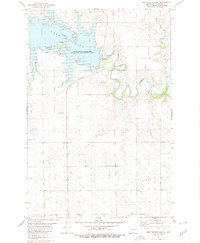
1980 Map of Heil
USGS Topo · Published 1980About this map
Heil serves as the primary hub of this Grant County landscape, situated along the Burlington Northern railroad corridor. The settlement is anchored by local history markers including Prairie View Cem and Peace Cem, which provide specific points of interest for genealogical research in this rural expanse. The geography is defined by the winding course of Antelope Creek, which meanders through terrain marked by distinctive heights like Elm Butte and the broad area identified as Buckskin.
Find a feature on this map
14 named features on this map. Tap any name to fly to it.
Don’t see what you’re looking for? This feature index may not catch every label — zoom into the map to look around manually.
Map Details
Editions of this 1980 Heil Map
This is the sole edition of this map. No revisions or reprints were ever made.
Other maps of this area

1938 · Heart Butte
USGS Topo · 1:48,000

1944 · Heart Butte
USGS Topo · 1:62,500

1954 · Bismarck
USGS Topo · 1:250,000

1958 · Bismarck
USGS Topo · 1:250,000

1972 · Carson SE
USGS Topo · 1:24,000

1972 · Leith
USGS Topo · 1:24,000

1972 · Sheep Creek Dam
USGS Topo · 1:24,000
1980 · Lake Tschida East
USGS Topo · 1:24,000

1980 · Crown Butte Creek SE
USGS Topo · 1:24,000

1980 · Crown Butte Creek SW
USGS Topo · 1:24,000