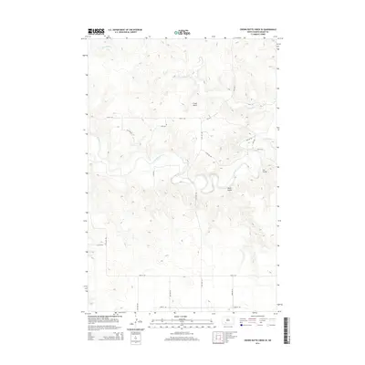
2014 Map of Crown Butte Creek SE
USGS Topo · Published 2014About this map
The winding Heart River meanders through the central portion of this Grant County landscape, creating a complex series of oxbows and riparian curves in an otherwise structured prairie. To the north, the elevation rises toward the prominent landmark of Crown Butte, a distinct topographic feature that overlooks the drainage of Crown Butte Cr. The land is defined by a rigid section-line road network, including 55th Ave and 57th St SW, which overlay a terrain deeply etched by drainage features such as Pump Coulee and Cat Coulee. This 2014 survey illustrates the persistence of traditional North Dakota ranching and agricultural land divisions, where the irregular natural path of the river contrasts sharply with the mathematical precision of the surrounding rural infrastructure and the localized relief of the buttes.
Find a feature on this map
20 named features on this map. Tap any name to fly to it.
Don’t see what you’re looking for? This feature index may not catch every label — zoom into the map to look around manually.
Map Details
Editions of this 2014 Crown Butte Creek SE Map
This is the sole edition of this map. No revisions or reprints were ever made.
Other maps of this area

1954 · Bismarck
USGS Topo · 1:250,000

1958 · Bismarck
USGS Topo · 1:250,000

1980 · Otter Creek West
USGS Topo · 1:24,000

1980 · Crown Butte Creek NW
USGS Topo · 1:24,000

1980 · Crown Butte Creek SE
USGS Topo · 1:24,000

1980 · Almont East
USGS Topo · 1:24,000

1980 · Lark
USGS Topo · 1:24,000

1980 · Heil
USGS Topo · 1:24,000

1980 · Crown Butte Creek SW
USGS Topo · 1:24,000
1980 · Almont West
USGS Topo · 1:24,000