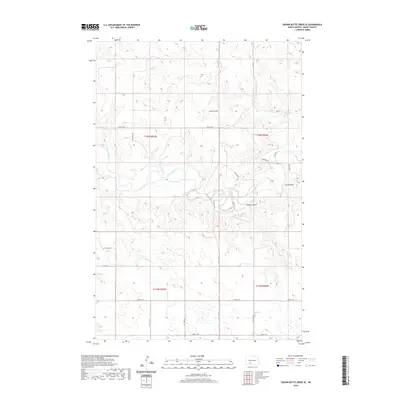
2020 Map of Crown Butte Creek SE
USGS Topo · Published 2020About this map
The Heart River winds through the rolling landscape of Grant County, cutting a path through the prairie terrain of southwest North Dakota. The topography is defined by significant landmarks like Crown Butte, which rises above the surrounding plains, and deep drainage features such as Pump Coulee and Cat Coulee. This 2020 record of the region illustrates a rural network of section-line roads, including 57th St SW and 62nd St SW, which serve the scattered agricultural holdings across townships T136N and T135N. The map provides a clear view of the modern land divisions and water resources that have shaped this portion of the Great Plains, where the river remains the primary natural focal point for the surrounding community.
Find a feature on this map
15 named features on this map. Tap any name to fly to it.
Don’t see what you’re looking for? This feature index may not catch every label — zoom into the map to look around manually.
Map Details
Editions of this 2020 Crown Butte Creek SE Map
This is the sole edition of this map. No revisions or reprints were ever made.
Other maps of this area

1954 · Bismarck
USGS Topo · 1:250,000

1958 · Bismarck
USGS Topo · 1:250,000

1980 · Otter Creek West
USGS Topo · 1:24,000

1980 · Crown Butte Creek NW
USGS Topo · 1:24,000

1980 · Crown Butte Creek SE
USGS Topo · 1:24,000

1980 · Almont East
USGS Topo · 1:24,000

1980 · Lark
USGS Topo · 1:24,000

1980 · Heil
USGS Topo · 1:24,000

1980 · Crown Butte Creek SW
USGS Topo · 1:24,000
1980 · Almont West
USGS Topo · 1:24,000