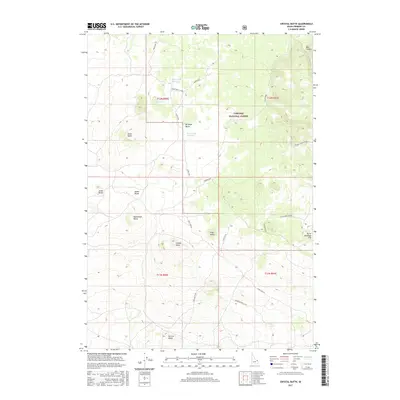
2017 Map of Crystal Butte
USGS Topo · Published 2017About this map
Targhee National Forest dominates the high-altitude landscape of this eastern Idaho terrain, characterized by a series of volcanic and geological formations. The area is defined by its prominent buttes, including Crystal Butte, Birdseye Butte, and Monument Butte, which serve as significant visual landmarks across the high desert and forest transition. The presence of a sequenced lake system—Davis Lake Number 1, Davis Lake Number 2, and Davis Lake Number 3—illustrates the region's unique hydrology, where water is often concentrated in these specific depressions. The map reveals a network of primitive access points such as the Bishop Well Cutoff and Bishop Burn, which trace the routes of early forest management and grazing access. This high-country layout, with its broad flats like North Antelope Flat, emphasizes the open, range-focused character of Fremont County during the early twenty-first century.
Find a feature on this map
26 named features on this map. Tap any name to fly to it.
Don’t see what you’re looking for? This feature index may not catch every label — zoom into the map to look around manually.
Map Details
Editions of this 2017 Crystal Butte Map
This is the sole edition of this map. No revisions or reprints were ever made.
Other maps of this area

1955 · Ashton
USGS Topo · 1:250,000

1958 · Ashton
USGS Topo · 1:250,000

1960 · Ashton
USGS Topo · 1:250,000
1965 · Split Butte
USGS Topo · 1:24,000

1965 · Blue Creek Reservoir
USGS Topo · 1:24,000
1965 · Icehouse Creek
USGS Topo · 1:24,000

1965 · Crystal Butte
USGS Topo · 1:24,000
1965 · Bishop Mountain
USGS Topo · 1:24,000

1965 · Sheridan Reservoir
USGS Topo · 1:24,000

1972 · Pine Butte
USGS Topo · 1:24,000