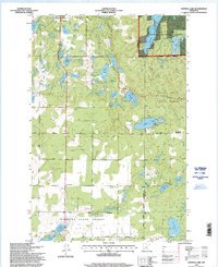
1996 Map of Crystal Lake
USGS Topo · Published 1998About this map
Akeley and Chamberlain sit at the center of a complex glacial landscape defined by its overlapping forest reserves and numerous kettle lakes. In the late 1990s, the region was managed through several dedicated state lands, including the Foot Hills State Forest, White Oak State Forest, Badoura State Forest, and Deerfield State Forest. The map reveals a transition from the structured street grid of Akeley near Akeley Cemetery to the more dispersed infrastructure of the surrounding timberlands, including a Landing Strip and isolated Gravel Pit operations. The drainage pattern is notable for its variety, from the larger Crystal Lake and Tenth Crow Wing Lake to the winding course of the Shingobee River and the secluded Howard Lake within the Chippewa National Forest. Local history and genealogy are anchored by sites such as the White Oak Cemetery, providing a specific geography for families rooted in these wooded lake lands.
Find a feature on this map
32 named features on this map. Tap any name to fly to it.
Don’t see what you’re looking for? This feature index may not catch every label — zoom into the map to look around manually.
Map Details
Editions of this 1996 Crystal Lake Map
This is the sole edition of this map. No revisions or reprints were ever made.
Other maps of this area

1953 · Brainerd
USGS Topo · 1:250,000

1954 · Bemidji
USGS Topo · 1:250,000

1957 · Brainerd
USGS Topo · 1:250,000

1957 · Bemidji
USGS Topo · 1:250,000

1958 · Bemidji
USGS Topo · 1:250,000

1958 · Brainerd
USGS Topo · 1:250,000

1965 · Brainerd
USGS Topo · 1:250,000

1970 · Backus
USGS Topo · 1:24,000

1970 · Hackensack
USGS Topo · 1:24,000

1970 · Nevis
USGS Topo · 1:24,000