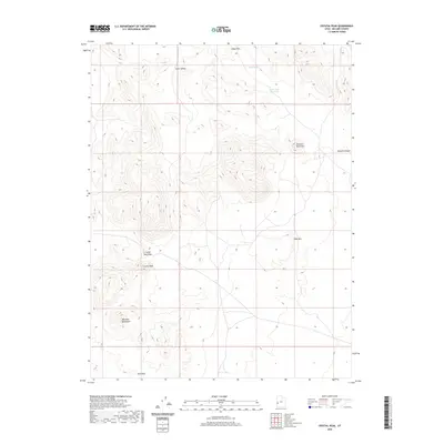
2020 Map of Crystal Peak
USGS Topo · Published 2020About this map
Crystal Peak serves as the central landmark for this arid section of Millard County, where the southern reaches of the Wah Wah Mountains meet a series of high basins and saddles. The topography is defined by strategic gaps in the landscape such as Snake Pass, Crystal Peak Pass, and Sand Pass, which have historically provided passage through these dry ranges. Human modification is sparse, represented primarily by the Snake Pass Reservoir and a handful of unimproved tracks that navigate the basin floors of Little Valley. This 2020 survey highlights the contrast between prominent heights like Table Mtn or Painted Rock Mtn and the drainage systems of Sand Wash and Smooth Canyon, providing a clear look at the area's natural gateways and seasonal water sources.
Find a feature on this map
11 named features on this map. Tap any name to fly to it.
Don’t see what you’re looking for? This feature index may not catch every label — zoom into the map to look around manually.
Map Details
Editions of this 2020 Crystal Peak Map
This is the sole edition of this map. No revisions or reprints were ever made.
Other maps of this area

1953 · Richfield
USGS Topo · 1:250,000

1958 · Richfield
USGS Topo · 1:250,000

1960 · Frisco Peak
USGS Topo · 1:62,500

1960 · Wah Wah Summit
USGS Topo · 1:62,500

1960 · Crystal Peak
USGS Topo · 1:62,500

1960 · The Barn
USGS Topo · 1:62,500

1980 · Wah Wah Mts. North
USGS Topo · 1:100,000
1989 · Pine Valley Hardpan North
USGS Topo · 1:24,000
1989 · Fifteenmile Point
USGS Topo · 1:24,000
1989 · Grassy Cove
USGS Topo · 1:24,000