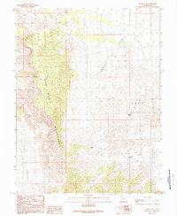
1989 Map of Grassy Cove
USGS Topo · Published 1989About this map
The Wah Wah Mountains dominate this 1989 provisional study, forming a high north-south spine that divides the arid basins of western Utah. This desert landscape is defined by its dramatic elevation changes, where the steep slopes of the range descend into Grassy Cove and the Gray Hills. In an area primarily shaped by natural topography rather than human settlement, the map reveals the critical importance of mountain crossings like Upper Pass and Middle Pass, which served as the primary conduits between Pine Valley to the west and the Wah Wah Valley to the east. The drainage patterns are clearly visible, with Lawson Cove Canyon cutting through the terrain toward the lower elevations of Lawson Cove, illustrating the geological forces that have sculpted this portion of Millard County.
Find a feature on this map
11 named features on this map. Tap any name to fly to it.
Don’t see what you’re looking for? This feature index may not catch every label — zoom into the map to look around manually.
Map Details
Editions of this 1989 Grassy Cove Map
This is the sole edition of this map. No revisions or reprints were ever made.
Other maps of this area

1953 · Richfield
USGS Topo · 1:250,000

1958 · Richfield
USGS Topo · 1:250,000

1960 · Frisco Peak
USGS Topo · 1:62,500

1960 · Wah Wah Summit
USGS Topo · 1:62,500

1960 · Crystal Peak
USGS Topo · 1:62,500

1960 · The Barn
USGS Topo · 1:62,500

1980 · Wah Wah Mts. North
USGS Topo · 1:100,000
1989 · Wah Wah Cove
USGS Topo · 1:24,000
1989 · Wah Wah Summit
USGS Topo · 1:24,000
1989 · Pine Valley Hardpan South
USGS Topo · 1:24,000