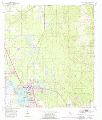
1954 Map of Crystal River
USGS Topo · Published 1988About this map
Crystal River sits at the heart of this coastal survey, where the freshwater discharge of Hunter Spring and Crystal Spring meets the brackish waters of Kings Bay. The geography is defined by an intricate network of waterways and wetlands, including Miller Creek and Bagley Cove, which weave around Buzzard Island and Banana Island. This 1950s depiction, later updated with photorevisions, shows the town during a period of mid-century growth. While the primary settlement clusters near the bay, the northern interior remains largely undeveloped, save for the community of Citronelle and several Sand Pits that suggest local resource extraction. The presence of a Trailer Park and Golf Course near the town center indicates the area's transition into a recreational and residential hub along the Florida Gulf Coast.
Find a feature on this map
19 named features on this map. Tap any name to fly to it.
Don’t see what you’re looking for? This feature index may not catch every label — zoom into the map to look around manually.
Map Details
Editions of this 1954 Crystal River Map
3 editions found
Other maps of this area

1892 · Dunnellon
USGS Topo · 1:62,500

1894 · Dunnellon
USGS Topo · 1:62,500

1895 · Tsala Apopka
USGS Topo · 1:62,500

1954 · Lecanto
USGS Topo · 1:24,000

1954 · Homosassa
USGS Topo · 1:24,000

1954 · Holder
USGS Topo · 1:24,000

1954 · Crystal River
USGS Topo · 1:24,000

1954 · Dunnellon
USGS Topo · 1:24,000

1954 · Red Level
USGS Topo · 1:24,000

1954 · Yankeetown SE
USGS Topo · 1:24,000