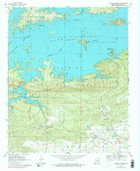
1962 Map of Crystal Springs
USGS Topo · Published 1978About this map
Lake Ouachita dominates this landscape, its complex shoreline and многочисленные islands defining the northern half of the survey. The map captures the interaction between the newly created reservoir and established settlements like Crystal Springs, where Crystal Springs Landing provided access to the water's edge. South of the lake, the terrain rises into the timbered heights of Bear Mountain and Hickorynut Mountain, areas largely contained within the Ouachita National Forest. This 1962 record reveals the rural fabric of Garland County through its dispersed family landmarks, including Brooks Cem and Lowe Cem. Local institutions such as Social Hill Ch and the Valley Sch anchor the small communities that remained after the valley's transformation, while industrial activity is noted at a local Gravel Pit.
Find a feature on this map
31 named features on this map. Tap any name to fly to it.
Don’t see what you’re looking for? This feature index may not catch every label — zoom into the map to look around manually.
Map Details
Editions of this 1962 Crystal Springs Map
4 editions found
Other maps of this area

1890 · Hot Springs
USGS Topo · 1:125,000

1894 · Hot Springs
USGS Topo · 1:125,000

1955 · Little Rock
USGS Topo · 1:250,000

1956 · Little Rock
USGS Topo · 1:250,000

1960 · Little Rock
USGS Topo · 1:250,000

1962 · Crystal Springs
USGS Topo · 1:24,000

1962 · Avant
USGS Topo · 1:24,000

1962 · Fannie
USGS Topo · 1:24,000

1962 · Mc Graw Mountain
USGS Topo · 1:24,000

1964 · Little Rock
USGS Topo · 1:250,000