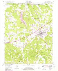
1948 Map of Cuba
USGS Topo · Published 1980About this map
Cuba serves as the primary hub of this Crawford County landscape, where the St Louis San Francisco railroad corridor and local highways converge. The topography is defined by the winding course of the Meramec River at the southern edge, while the interior is dotted with rural institutions that reveal the area's mid-century social fabric. Small educational centers like Maple Shade Sch and Fanning Sch are scattered across the map, alongside several family-named burial grounds including Fairclough Cem and Zenser Cem. This edition includes later revisions that note modern developments such as a Drive-In Theater and the Flutterbugs Roost Landing Strip, illustrating the gradual transition from a purely agricultural and rail-based economy toward the growth of localized leisure and aviation infrastructure near Cuba Municipal Airport.
Find a feature on this map
37 named features on this map. Tap any name to fly to it.
Don’t see what you’re looking for? This feature index may not catch every label — zoom into the map to look around manually.
Map Details
Editions of this 1948 Cuba Map
5 editions found
Other maps of this area

1903 · Sullivan
USGS Topo · 1:125,000

1928 · Meramec Spring
USGS Topo · 1:62,500

1932 · Steelville
USGS Topo · 1:48,000

1933 · Steelville
USGS Topo · 1:62,500

1934 · Redbird
USGS Topo · 1:62,500

1937 · Steelville
USGS Topo · 1:62,500

1938 · Redbird
USGS Topo · 1:62,500

1948 · Cuba
USGS Topo · 1:24,000

1948 · Leasburg
USGS Topo · 1:24,000

1948 · Argo
USGS Topo · 1:24,000