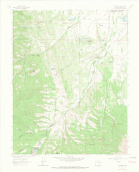
1963 Map of Cuchara
USGS Topo · Published 1966About this map
The San Isabel National Forest landscape shown here in the early 1960s is defined by the narrow valley of the Cucharas River and the high ridges of the Sangre de Cristo Mountains. The settlement of Cuchara serves as the focal point for this mountain community, surrounded by geological landmarks like Goemmer Butte and the sheer vertical formations known as the Devils Stairsteps. Resource extraction and water management are evident throughout the terrain, from the Copper King Mine and Linscott Mine tucked into canyons to high-altitude reservoirs like HR Carson Reservoir and Mc Donald Reservoir. A network of Jeep Trails provides the primary means of navigating the steep elevation changes between Raspberry Mountain and the Black Hills, reflecting the area's mid-century character as a hub for both mining history and mountain recreation.
Find a feature on this map
39 named features on this map. Tap any name to fly to it.
Don’t see what you’re looking for? This feature index may not catch every label — zoom into the map to look around manually.
Map Details
Editions of this 1963 Cuchara Map
4 editions found
Other maps of this area

1889 · Huerfano Park
USGS Topo · 1:125,000

1891 · Walsenburg
USGS Topo · 1:125,000

1891 · Spanish Peaks
USGS Topo · 1:125,000

1892 · Huerfano Park
USGS Topo · 1:125,000

1893 · Spanish Peaks
USGS Topo · 1:125,000

1894 · Walsenburg
USGS Topo · 1:125,000

1895 · Spanish Peaks
USGS Topo · 1:125,000

1897 · Walsenburg
USGS Topo · 1:125,000

1897 · Spanish Peaks
USGS Topo · 1:125,000

1900 · Spanish Peaks
USGS Topo · 1:125,000