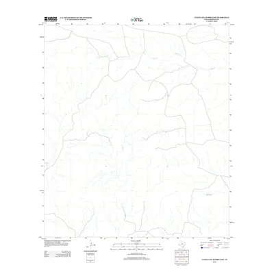
2012 Map of Cuesta Del Burro East
USGS Topo · Published 2012About this map
Cibolo Cr and Perdiz Cr define the drainage patterns of this arid Presidio County landscape. This 2012 survey highlights a remote section of the Big Bend region where seasonal watercourses and primitive roads are the primary features. The isolation of the territory is reflected in the sparsity of named locations, with Allison Ranch standing as the lone named settlement on the sheet. The map reveals the intricate network of arroyos and canyons that feed into the larger creek systems, illustrating the topographical complexity of the Texas desert. Researchers and land owners can trace the relationship between these natural water features and the historical ranching infrastructure that has persisted in this corner of the state into the twenty-first century.
Find a feature on this map
3 named features on this map. Tap any name to fly to it.
Don’t see what you’re looking for? This feature index may not catch every label — zoom into the map to look around manually.
Map Details
Editions of this 2012 Cuesta Del Burro East Map
This is the sole edition of this map. No revisions or reprints were ever made.
Other maps of this area

1895 · Marfa
USGS Topo · 1:125,000

1896 · Shafter
USGS Topo · 1:125,000

1959 · Presidio
USGS Topo · 1:250,000

1959 · Marfa
USGS Topo · 1:250,000

1965 · Presidio
USGS Topo · 1:250,000

1965 · Marfa
USGS Topo · 1:250,000
1979 · Chinati Peak
USGS Topo · 1:24,000

1983 · Cuesta Del Burro East
USGS Topo · 1:24,000
1983 · Cuesta Del Burro NW
USGS Topo · 1:24,000
1983 · Cerros Prietos
USGS Topo · 1:24,000