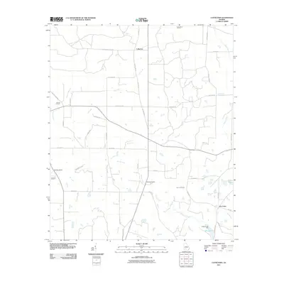
2011 Map of Cuffietown
USGS Topo · Published 2011About this map
Cuffietown and the surrounding South Georgia rural landscape are defined by a complex network of small waterways and local farm roads. In the early 21st century, the region's agricultural character is preserved through family-named routes such as Jodie Hobby Rd and Charlie Lamb Rd. The drainage pattern is led by the Little River and Abrams Creek, with smaller tributaries like Red Oak Branch and Big Branch feeding local reservoirs including Nelson Lake and Williams Lake. Evidence of early community centers is preserved at scattered burial grounds like Rocky Mount Cemetery and Providence Cemetery. Infrastructure in this period remains focused on local connectivity, as seen at Whiddon Bridge and Beckman Bridge, which facilitate travel across the many creek crossings that segment the terrain.
Find a feature on this map
49 named features on this map. Tap any name to fly to it.
Don’t see what you’re looking for? This feature index may not catch every label — zoom into the map to look around manually.
Map Details
Editions of this 2011 Cuffietown Map
This is the sole edition of this map. No revisions or reprints were ever made.
Other maps of this area

1953 · Waycross
USGS Topo · 1:250,000

1956 · Sylvester
USGS Topo · 1:62,500

1958 · Waycross
USGS Topo · 1:250,000

1972 · Cuffietown
USGS Topo · 1:24,000

1973 · Sumner
USGS Topo · 1:24,000
1973 · Acree
USGS Topo · 1:24,000

1973 · Sylvester
USGS Topo · 1:24,000
1973 · Doles
USGS Topo · 1:24,000

1973 · Ashburn
USGS Topo · 1:24,000
1977 · Arabi
USGS Topo · 1:24,000