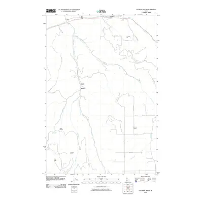
2010 Map of Culdesac South
USGS Topo · Published 2010About this map
Slickpoo and the surrounding plateau of Nez Perce County are defined by a network of steep canyons and winding grade roads that negotiate the dramatic elevation changes of northern Idaho. In the early 21st century, the landscape is structured by waterways like Mission Creek and Rock Creek, which cut deep paths through the terrain toward the northern settlements of Culdesac and Jacques. Notable landmarks such as the Forest Lawn Cemetery and the Longcamp Access Area provide specific points of interest for local history and recreation.
Find a feature on this map
34 named features on this map. Tap any name to fly to it.
Don’t see what you’re looking for? This feature index may not catch every label — zoom into the map to look around manually.
Map Details
Editions of this 2010 Culdesac South Map
This is the sole edition of this map. No revisions or reprints were ever made.
Other maps of this area

1946 · Limekiln Rapids
USGS Topo · 1:62,500

1955 · Pullman
USGS Topo · 1:250,000

1958 · Pullman
USGS Topo · 1:250,000

1958 · Lapwai
USGS Topo · 1:24,000

1958 · Sweetwater
USGS Topo · 1:24,000

1958 · Lewiston Orchards
USGS Topo · 1:62,500

1958 · Culdesac
USGS Topo · 1:62,500
1967 · Winchester East
USGS Topo · 1:24,000

1968 · Waha
USGS Topo · 1:24,000
1968 · Winchester West
USGS Topo · 1:24,000