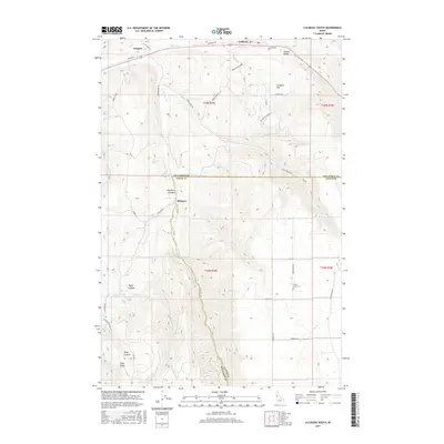
2017 Map of Culdesac South
USGS Topo · Published 2017About this map
Culdesac sits at the northern edge of this high-relief landscape where the Lapwai Valley transitions into the steep drainages of the Nez Perce and Lewis county line. The topography is defined by significant elevation changes, from the heights of Culdesac Hill down through deeply incised features like Hamilton Canyon and Taylor Canyon. The settlement pattern reflects the area's agricultural and mission history, anchored by the community of Slickpoo and the small siding at Jacques.
Find a feature on this map
42 named features on this map. Tap any name to fly to it.
Don’t see what you’re looking for? This feature index may not catch every label — zoom into the map to look around manually.
Map Details
Editions of this 2017 Culdesac South Map
This is the sole edition of this map. No revisions or reprints were ever made.
Other maps of this area

1946 · Limekiln Rapids
USGS Topo · 1:62,500

1955 · Pullman
USGS Topo · 1:250,000

1958 · Pullman
USGS Topo · 1:250,000

1958 · Lapwai
USGS Topo · 1:24,000

1958 · Sweetwater
USGS Topo · 1:24,000

1958 · Lewiston Orchards
USGS Topo · 1:62,500

1958 · Culdesac
USGS Topo · 1:62,500
1967 · Winchester East
USGS Topo · 1:24,000

1968 · Waha
USGS Topo · 1:24,000
1968 · Winchester West
USGS Topo · 1:24,000