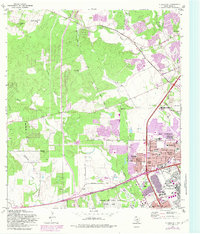
1966 Map of Culebra Hill
USGS Topo · Published 1983About this map
Lackland Air Force Base dominates the southeastern quadrant of this study, showcasing its expansive Training Annex and adjacent military housing developments like Lackland City and Lackland Terrace. The map illustrates the suburban expansion of western San Antonio during the mid-1960s, with newer residential subdivisions such as Westwood Village and Kelland Heights emerging near major arteries like Marbach Road.
Find a feature on this map
55 named features on this map. Tap any name to fly to it.
Don’t see what you’re looking for? This feature index may not catch every label — zoom into the map to look around manually.
Map Details
Editions of this 1966 Culebra Hill Map
Other maps of this area

1953 · Culebra Hill
USGS Topo · 1:24,000

1953 · San Antonio West
USGS Topo · 1:24,000

1953 · Terrell Wells
USGS Topo · 1:24,000

1953 · Macdona
USGS Topo · 1:24,000

1953 · Helotes
USGS Topo · 1:24,000

1953 · Castle Hills
USGS Topo · 1:24,000

1954 · San Antonio
USGS Topo · 1:250,000

1956 · Medina Lake
USGS Topo · 1:62,500

1957 · San Antonio
USGS Topo · 1:250,000

1958 · La Coste
USGS Topo · 1:24,000