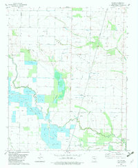
1982 Map of Culler
USGS Topo · Published 1982About this map
Bayou Meto and its intricate network of tributaries dominate this landscape on the border of Lonoke and Arkansas counties. In the early 1980s, the region shows a sophisticated water management system characterized by numerous Fish Farms and drainage features like the Blue Point Ditch and Fishtrap Slough. The small settlement of Culler serves as a local landmark alongside the Pleasant Grove Ch, illustrating the rural social fabric of the era.
Find a feature on this map
24 named features on this map. Tap any name to fly to it.
Don’t see what you’re looking for? This feature index may not catch every label — zoom into the map to look around manually.
Map Details
Editions of this 1982 Culler Map
This is the sole edition of this map. No revisions or reprints were ever made.
Other maps of this area

1935 · Hazen
USGS Topo · 1:62,500

1937 · Stuttgart
USGS Topo · 1:62,500

1937 · England
USGS Topo · 1:48,000

1939 · Stuttgart
USGS Topo · 1:62,500

1940 · Lonoke
USGS Topo · 1:62,500

1941 · Hazen
USGS Topo · 1:62,500

1943 · England
USGS Topo · 1:62,500

1948 · Helena
USGS Topo · 1:250,000

1949 · Lonoke
USGS Topo · 1:62,500

1950 · Helena
USGS Topo · 1:250,000