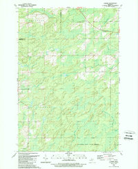
1989 Map of Cunard
USGS Topo · Published 1989About this map
Cunard and Blom stand as the primary reference points in this late-century topographic study of the Upper Peninsula’s borderlands. The landscape is defined by an intricate network of waterways draining toward the Little Cedar River and Cedar River, including numerous spring-fed tributaries like Mullen Spring and Harter Creek. Large portions of the terrain are protected within the Escanaba River State Forest, where the topography is shaped by countless small depressions and wetlands common to the Faithorn and Meyer townships.
Find a feature on this map
30 named features on this map. Tap any name to fly to it.
Don’t see what you’re looking for? This feature index may not catch every label — zoom into the map to look around manually.
Map Details
Editions of this 1989 Cunard Map
This is the sole edition of this map. No revisions or reprints were ever made.
Other maps of this area

1939 · Pembine
USGS Topo · 1:48,000

1947 · Pembine
USGS Topo · 1:48,000

1954 · Escanaba
USGS Topo · 1:250,000

1955 · Vulcan
USGS Topo · 1:24,000

1955 · Norway
USGS Topo · 1:62,500

1956 · Foster City
USGS Topo · 1:62,500

1957 · Escanaba
USGS Topo · 1:250,000

1958 · Escanaba
USGS Topo · 1:250,000

1963 · Pembine
USGS Topo · 1:62,500

1963 · Powers
USGS Topo · 1:62,500