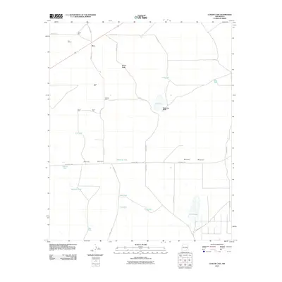
2010 Map of Curlew Lake
USGS Topo · Published 2010About this map
Boaz sits in the northwest corner of this high plains landscape, defined by a sparse network of county roads and a critical water infrastructure of wells and tanks. The terrain is characterized by broad basins such as Curlew Lake and Salt Lake, which punctuate the arid Chaves County soil. A notable cultural landmark is the Boaz Cemetery, serving as a genealogical anchor for the small settlement. To the south, Railroad Mountain rises as a distinct topographical feature, flanked by Railroad Mt Rd. The abundance of named water sources, from Beatty Wells to McDowell Tank, reveals the area's historical reliance on groundwater for ranching and survival. This survey captures a moment in the early 21st century when these remote outposts and family-named landmarks like McCarter Well and Robertson Wells remained the primary identifiers for this expansive rural territory.
Find a feature on this map
32 named features on this map. Tap any name to fly to it.
Don’t see what you’re looking for? This feature index may not catch every label — zoom into the map to look around manually.
Map Details
Editions of this 2010 Curlew Lake Map
This is the sole edition of this map. No revisions or reprints were ever made.
Other maps of this area

1954 · Brownfield
USGS Topo · 1:250,000

1955 · Roswell
USGS Topo · 1:250,000

1958 · Brownfield
USGS Topo · 1:250,000

1958 · Roswell
USGS Topo · 1:250,000

1962 · Roswell
USGS Topo · 1:250,000

1962 · Brownfield
USGS Topo · 1:250,000

1967 · Elkins
USGS Topo · 1:24,000
1967 · Denton Camp
USGS Topo · 1:24,000
1967 · Sardine Lake
USGS Topo · 1:24,000

1978 · Curlew Lake
USGS Topo · 1:24,000