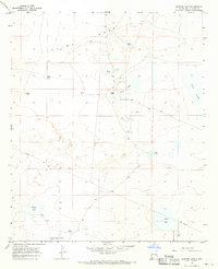
1967 Map of Sardine Lake
USGS Topo · Published 1971About this map
O'Brien Ranch and the small settlement of O'Brien center this arid Chaves County landscape, where survival is clearly tied to a complex network of water management features. The terrain is dominated by the prominent Mesa Palma to the north and the ephemeral Long Arroyo Draw to the south. This late 1960s survey documents a working ranching and industrial environment, illustrated by numerous stock tanks such as Moon Tank, Wolf Tank, and the curiously named Madison Square Garden Tank. Beyond ranching, the map traces the footprint of the mid-century energy industry through scattered Oil Wells and a significant Pipeline cutting across the southern sections. Notable landmarks for local history include a remote Landing Strip and several named basins like Sardine Lake, Twin Lakes, and Red Lake.
Find a feature on this map
23 named features on this map. Tap any name to fly to it.
Don’t see what you’re looking for? This feature index may not catch every label — zoom into the map to look around manually.
Map Details
Editions of this 1967 Sardine Lake Map
2 editions found
Other maps of this area

1949 · Sardine Mountain
USGS Topo · 1:24,000

1949 · L-E Ranch
USGS Topo · 1:24,000

1954 · Brownfield
USGS Topo · 1:250,000

1955 · Roswell
USGS Topo · 1:250,000

1958 · Brownfield
USGS Topo · 1:250,000

1958 · Roswell
USGS Topo · 1:250,000

1962 · Roswell
USGS Topo · 1:250,000

1962 · Brownfield
USGS Topo · 1:250,000
1967 · Campbell
USGS Topo · 1:24,000

1967 · Haystack Mountain
USGS Topo · 1:24,000