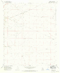
1967 Map of Campbell
USGS Topo · Published 1971About this map
The Atchison Topeka and Santa Fe railroad cuts across this arid landscape of Chaves County, establishing a vital transportation link through the high plains. The small settlement of Campbell and the nearby Sterling Ranch reflect a ranching economy that relies heavily on a network of water features including West Windmill, North Windmill Well, and White Tank to sustain operations in a region of limited surface water.
Find a feature on this map
18 named features on this map. Tap any name to fly to it.
Don’t see what you’re looking for? This feature index may not catch every label — zoom into the map to look around manually.
Map Details
Editions of this 1967 Campbell Map
2 editions found
Other maps of this area

1949 · Sardine Mountain
USGS Topo · 1:24,000

1949 · L-E Ranch
USGS Topo · 1:24,000

1950 · Comanche Spring
USGS Topo · 1:24,000

1955 · Roswell
USGS Topo · 1:250,000

1958 · Roswell
USGS Topo · 1:250,000

1962 · Roswell
USGS Topo · 1:250,000

1962 · Eightmile Draw
USGS Topo · 1:24,000

1962 · Acme
USGS Topo · 1:24,000

1967 · Haystack Mountain
USGS Topo · 1:24,000

1967 · Elkins
USGS Topo · 1:24,000