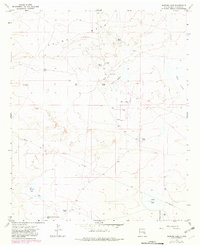
1967 Map of Sardine Lake
USGS Topo · Published 1982About this map
O'Brien Ranch sits at the heart of this high-plains landscape, where the management of water defines every ranching operation. The terrain is marked by a series of shallow basins and depressions including Sardine Lake, Adobe Lake, Deep Lake, and the expansive Red Lake to the east. A network of named catchments such as Moon Tank, Wolf Tank, and the curiously named Madison Square Garden Tank highlights the critical importance of water storage for livestock in the arid Chaves County environment.
Find a feature on this map
22 named features on this map. Tap any name to fly to it.
Don’t see what you’re looking for? This feature index may not catch every label — zoom into the map to look around manually.
Map Details
Editions of this 1967 Sardine Lake Map
2 editions found
Other maps of this area

1949 · Sardine Mountain
USGS Topo · 1:24,000

1949 · L-E Ranch
USGS Topo · 1:24,000

1954 · Brownfield
USGS Topo · 1:250,000

1955 · Roswell
USGS Topo · 1:250,000

1958 · Brownfield
USGS Topo · 1:250,000

1958 · Roswell
USGS Topo · 1:250,000

1962 · Roswell
USGS Topo · 1:250,000

1962 · Brownfield
USGS Topo · 1:250,000
1967 · Campbell
USGS Topo · 1:24,000

1967 · Haystack Mountain
USGS Topo · 1:24,000