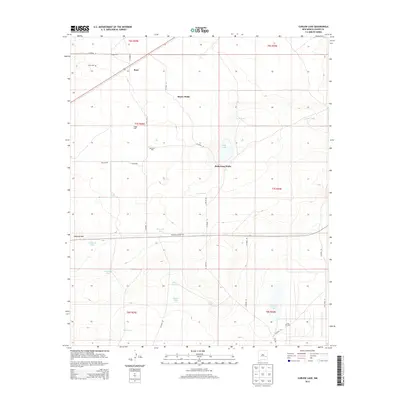
2013 Map of Curlew Lake
USGS Topo · Published 2013About this map
Boaz and its surrounding ranchlands characterize this portion of Chaves County, where water management is the primary driver of human settlement. The map reveals a sophisticated network of water infrastructure across the high plains, featuring a high density of named stock tanks and wells such as Savage Well, Beatty Wells, and McDowell Tank. These water sources, crucial for the local livestock industry, are scattered around distinct natural features like the ephemeral Curlew Lake and the low rise of Railroad Mtn.
Find a feature on this map
40 named features on this map. Tap any name to fly to it.
Don’t see what you’re looking for? This feature index may not catch every label — zoom into the map to look around manually.
Map Details
Editions of this 2013 Curlew Lake Map
This is the sole edition of this map. No revisions or reprints were ever made.
Other maps of this area

1954 · Brownfield
USGS Topo · 1:250,000

1955 · Roswell
USGS Topo · 1:250,000

1958 · Brownfield
USGS Topo · 1:250,000

1958 · Roswell
USGS Topo · 1:250,000

1962 · Roswell
USGS Topo · 1:250,000

1962 · Brownfield
USGS Topo · 1:250,000

1967 · Elkins
USGS Topo · 1:24,000
1967 · Denton Camp
USGS Topo · 1:24,000
1967 · Sardine Lake
USGS Topo · 1:24,000

1978 · Curlew Lake
USGS Topo · 1:24,000